River Nile

This is the latest accepted revision, accepted on 8 August 2010. Jump to: navigation, search For other uses, see Nile (disambiguation). Coordinates: 30°10′N 31°6′E / 30.167°N 31.1°E / 30.167; 31.1 Nile River The Nile in Egypt Name origin: "Nile"(Arabic: 'nīl) comes from the Greek word Neilos (Νεῖλος) Countries Ethiopia, Sudan, Egypt, Uganda, Democratic Republic of the Congo Cities Jinja, Juba, Khartoum, Cairo Primary source White Nile - elevation 2,700 m (8,858 ft) - coordinates 2°16′55.92″S 29°19′52.32″E / 2.2822°S 29.3312°E / -2.2822; 29.3312 Secondary source Blue Nile - location Lake Tana, Ethiopia - coordinates 12°2′8.8″N 37°15′53.11″E / 12.035778°N 37.2647528°E / 12.035778; 37.2647528 Source confluence near Khartoum Mouth - location Mediterranean Sea - elevation 0 m (0 ft) - coordinates 30°10′N 31°6′E / 30.167°N 31.1°E / 30.167; 31.1 [1] Length 6,650 km (4,132 mi) Width 8 km (5 mi) Basin 3,400,000 km2 (1,312,747 sq mi) Discharge - average 2,830 m3/s (99,941 cu ft/s) Map showing the Nile The Nile (Arabic: النيل, an-nīl, Ancient Egyptian iteru or Ḥ'pī, Coptic piaro or phiaro) is a major north-flowing river in Africa, generally regarded as the longest river in the world.
The Nile has two major tributaries, the White Nile and Blue Nile, the latter being the source of most of the Nile's water and fertile soil, but the former being the longer of the two. The White Nile rises in the Great Lakes region of central Africa, with the most distant source in southern Rwanda at 2°16′55.92″S 29°19′52.32″E / 2.2822°S 29.3312°E / -2.2822; 29.3312, and flows north from there through Tanzania, Lake Victoria, Uganda and southern Sudan, while the Blue Nile starts at Lake Tana in Ethiopia at 12°2′8.8″N 37°15′53.11″E / 12.035778°N 37.2647528°E / 12.035778; 37.2647528, flowing into Sudan from the southeast. The two rivers meet near the Sudanese capital of Khartoum.
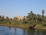
The northern section of the river flows almost entirely through desert, from Sudan into Egypt, a country whose civilization has depended on the river since ancient times. Most of the population and cities of Egypt lie along those parts of the Nile valley north of Aswan, and nearly all the cultural and historical sites of Ancient Egypt are found along the banks of the river. The Nile ends in a large delta that empties into the Mediterranean Sea.
// [edit] Etymology of the word Nile The word "Nile" comes from Greek Neilos (Νεῖλος), of unknown derivation. In the ancient Egyptian language, the Nile is called Ḥ'pī or iteru, meaning "great river", represented by the hieroglyphs shown on the right (literally itrw, and 'waters' determinative). In Coptic, the words piaro (Sahidic) or phiaro (Bohairic) meaning "the river" (lit. p(h).iar-o "the.canal-great") come from the same ancient name.
[edit] Tributaries and distributaries Nile seen from Spot Satellite Map showing the course of the White and Blue Niles. The Nile makes its way through the Sahara The drainage basin of the Nile covers 3,254,555 square kilometres (1,256,591 sq mi), about 10% of the area of Africa.
There are two great tributaries of the Nile, joining at Khartoum: the White Nile, starting in equatorial East Africa, and the Blue Nile, beginning in Ethiopia. Both branches are on the western flanks of the East African Rift, the southern part of the Great Rift Valley. Below the Blue and White Nile confluence the only remaining major tributary is the Atbara River, which originates in Ethiopia north of Lake Tana, and is around 800 kilometres (500 mi) long. During the dry period of January to June, there is typically no flow from the Atbara River. It flows only while there is rain in Ethiopia and dries very rapidly. It joins the Nile approximately 300 kilometres (200 mi) north of Khartoum.
The Nile is unusual in that its last tributary (the Atbara) joins it roughly halfway to the sea. From that point north, the Nile diminishes because of evaporation.
The course of the Nile in Sudan is distinctive. It flows over six groups of cataracts, from the first at Aswan to the sixth at Sabaloka (just north of Khartoum) and then turns to flow southward for a good portion of its course, before again returning to flow north to the sea. This is called the "Great Bend of the Nile".
North of Cairo, the Nile splits into two branches (or distributaries) that feed the Mediterranean: the Rosetta Branch to the west and the Damietta to the east, forming the Nile Delta.
The Nile basin is complex, and because of this, the discharge at any given point along the mainstem depends on many factors including weather, diversions, evaporation and evapotranspiration, and groundwater flow.
White Nile The source of the Nile is sometimes considered to be Lake Victoria, but the lake itself has feeder rivers of considerable size. The most distant stream—and thus the ultimate source of the Nile—emerges from Nyungwe Forest in Rwanda, via the Rukarara, Mwogo, Nyabarongo and Kagera rivers, before flowing into Lake Victoria in Tanzania near the town of Bukoba.
The Nile leaves Lake Victoria at Ripon Falls near Jinja, Uganda, as the Victoria Nile. It flows for approximately 500 kilometres (300 mi) farther, through Lake Kyoga, until it reaches Lake Albert. After leaving Lake Albert, the river is known as the Albert Nile. It then flows into Sudan, where it is known as the Bahr al Jabal ("River of the Mountain"). The Bahr al Ghazal, itself 716 kilometres (445 mi) long, joins the Bahr al Jabal at a small lagoon called Lake No, after which the Nile becomes known as the Bahr al Abyad, or the White Nile, from the whitish clay suspended in its waters. When the Nile flooded it left a rich silty deposit which fertilised the soil. The Nile no longer floods annually since the completion of the Aswan Dam in 1970. From Lake No, the river flows to Khartoum. An anabranch river, the Bahr el Zeraf, flows out of the Nile's Bahr al Jabal section and rejoins the White Nile.
The term "White Nile" is used in both a general sense, referring to the entire river above Khartoum, and in a limited sense, describing the section between Lake No and Khartoum.
The flow rate of the Bahr al Jebal at Mongalla, Sudan is almost constant throughout the year and averages 1,048 m3/s (37,000 cu ft/s). After Mongalla, the Bahr Al Jabal enters the enormous swamps of the Sudd region of Sudan. More than half of the Nile's water is lost in this swamp to evaporation and transpiration. The average flow rate of the White Nile at the tails of the swamps is about 510 m3/s (18,000 cu ft/s). From here it soon meets with the Sobat River at Malakal. On an annual basis the White Nile upstream of Malakal contributes about 15% of the total outflow of the Nile River.
The Bahr al Jebal and the Sobat River are the two most important tributaries of the White Nile in terms of discharge. The Bahr al Ghazal's drainage basin is the largest of any of the Nile's sub-basins, measuring 520,000 square kilometres (200,000 sq mi) in size, but it contributes a relatively small amount of water, about 2 m3/s (71 cu ft/s) annually, due to tremendous volumes of water being lost in the Sudd wetlands. The Sobat River, which joins the Nile a short distance below Lake No, drains about half as much land, 225,000 km2 (86,900 sq mi), but contributes 412 cubic metres per second (14,500 cu ft/s) annually to the Nile. When in flood the Sobat carries a large amount of sediment, adding greatly to the White Nile's color.
The average flow of the White Nile at Malakal, just below the Sobat River, is 924 m3/s (32,600 cu ft/s); the peak flow is approximately 1,218 m3/s (43,000 cu ft/s) in October and minimum flow is about 609 m3/s (21,500 cu ft/s) in April. This fluctuation is due the substantial variation in the flow of the Sobat, which has a minimum flow of about 99 m3/s (3,500 cu ft/s) in March and a peak flow of over 680 m3/s (24,000 cu ft/s) in October . During the dry season (January to June) the White Nile contributes between 70% and 90% of the total discharge from the Nile.
Blue Nile Main article: Blue Nile The Blue Nile Falls fed by Lake Tana near the city of Bahir Dar, Ethiopia. Nile delta from space The Blue Nile (Ge'ez ጥቁር ዓባይ Ṭiqūr ʿĀbbāy (Black Abay) to Ethiopians; Arabic: النيل الأزرق; transliterated: an-Nīl al-Azraq) springs from Lake Tana in the Ethiopian Highlands. The Blue Nile flows about 1,400 kilometres (870 mi) to Khartoum, where the Blue Nile and White Nile join to form the Nile. 90% of the water and 96% of the transported sediment carried by the Nileoriginates in Ethiopia, with 59% of the water from the Blue Nile (the rest being from the Tekezé, Atbarah, Sobat, and small tributaries). The erosion and transportation of silt only occurs during the Ethiopian rainy season in the summer, however, when rainfall is especially high on the Ethiopian Plateau; the rest of the year, the great rivers draining Ethiopia into the Nile (Sobat, Blue Nile, Tekezé, and Atbarah) have a weaker flow.
The Blue Nile contributes approximately 80-90% of the Nile River discharge. The flow of the Blue Nile varies considerably over its yearly cycle and is the main contribution to the large natural variation of the Nile flow. During the wet season the peak flow of the Blue Nile will often exceed 5,663 m3/s (200,000 cu ft/s) in late August (a difference of a factor of 50). During the dry season the natural discharge of the Blue Nile can be as low as 113 m3/s (4,000 cu ft/s), although upstream dams regulate the flow of the river.
Before the placement of dams on the river the yearly discharge varied by a factor of 15 at Aswan. Peak flows of over 8,212 m3/s (290,000 cu ft/s) would occur during late August and early September and minimum flows of about 552 m3/s (19,500 cu ft/s) would occur during late April and early May.
Yellow Nile The Yellow Nile is a former tributary that connected the Ouaddaï Highlands of eastern Chad to the Nile River Valley ca. 8000 to ca. 1000 BCE. Its remains are known as the Wadi Howar. The wadi passes through Gharb Darfur near the northern border with Chad and meets up with the Nile near the southern point of the Great Bend.
Lost headwaters Further information: List of rivers by length Formerly Lake Tanganyika drained northwards along the African Rift Valley into the Albert Nile, making the Nile about 900 miles (1,400 km) longer, until blocked in Miocene times by the bulk of the Virunga Volcanoes.
History Reconstruction of the Oikoumene (inhabited world), an ancient map based on Herodotus' description of the world, circa 450 BCE. Historic map of the River Nile by Piri Reis Further information: Climate history of the Sahara The Nile (iteru in Ancient Egyptian) has been the lifeline of civilization in Egypt since the Stone Age, with most of the population and all of the cities of Egypt resting along those parts of the Nile valley lying north of Aswan. Climate change at the end of the most recent ice age led to the formation of the Sahara desert, possibly as long ago as 3400 BC.
The Eonile The present Nile is at least the fifth river that has flowed north from the Ethiopian Highlands. Satellite imagery was used to identify dry watercourses in the desert to the west of the Nile. An Eonile canyon, now filled by surface drift, represents an ancestral Nile called the Eonile that flowed during the later Miocene (23–5.3 million years before present). The Eonile transported clastic sediments to the Mediterranean; several natural gas fields have been discovered within these sediments.
During the late-Miocene Messinian salinity crisis, when the Mediterranean Sea was a closed basin and evaporated to the point of being empty or nearly so, the Nile cut its course down to the new base level until it was several hundred feet below world ocean level at Aswan and 8,000 feet (2,400 m) below Cairo. This created a very long and deep canyon which was filled with sediment when the Mediterranean was recreated. At some point the sediments raised the riverbed sufficiently for the river to overflow westward into a depression to create Lake Moeris.
Lake Tanganyika drained northwards into the Nile until the Virunga Volcanoes blocked its course in Rwanda. The Nile was much longer at that time, with its furthest headwaters in northern Zambia.
The integrated Nile There are two theories in relation to the age of the integrated Nile. The first one is that the integrated drainage of the Nile is of young age, and that the Nile basin was formerly broken into series of separate basins, only the most northerly of which fed a river following the present course of the Nile in Egypt and Sudan. Said (1981) postulates that Egypt itself supplied most of the waters of the Nile during the early part of its history.
The other theory is that the drainage from Ethiopia via rivers equivalent to the Blue Nile and the Atbara and Takazze flowed to the Mediterranean via the Egyptian Nile since well back into Tertiary times.
Salama (1987) suggested that during the Tertiary (65 million to 2.588 million years ago) there were a series of separate closed continental basins, with each basin occupying one of the major parts of the Sudanese Rift System: Mellut Rift, White Nile Rift, Blue Nile Rift, Atbara Rift and Sag El Naam Rift. The Mellut Rift Basin is nearly 12 km deep at its central part. This rift is possibly still active, with reported tectonic activity in its northern and southern boundaries. The Sudd swamps which form the central part of the basin may still be subsiding. The White Nile Rift System, although shallower than Bahr al-Arab, is about 9 km deep. Geophysical exploration of the Blue Nile Rift System estimated the depth of the sediments to be 5–9 km. These basins were not interconnected until their subsidence ceased, and the rate of sediment deposition was enough to fill up the basins to such a level that the basins became connected. The Egyptian Nile became connected to the Sudanese Nile, which captures the Ethiopian and Equatorial head waters during the current stages of tectonic activity in the Eastern, Central and Sudanese Rift Systems.[14] The connection of the different Niles occurred during cyclic wet periods. The River Atbara overflowed its closed basin during the wet periods which occurred about 100,000 to 120,000 years ago. The Blue Nile was connected to the main Nile during the 70,000–80,000 years B.P. wet period. The White Nile system in Bahr El Arab and White Nile Rifts remained a closed lake until the connection of the Victoria Nile to the main system some 12,500 years ago.
Role in the founding of Egyptian civilization The Greek historian Herodotus wrote that "Egypt was the gift of the Nile". An unending source of sustenance, it provided a crucial role in the development of Egyptian civilization. Silt deposits from the Nile made the surrounding land extremely fertile because the river overflowed its banks annually. The Ancient Egyptians were able to cultivate wheat and other crops around the Nile. Flax was grown, mostly for trade. Wheat was also traded; it was a crucial crop in the Middle East where famine was very common. This trading system secured the diplomatic relationship Egypt had with other countries, and contributed to Egypt's economic stability. That far-reaching trade has been carried on along the Nile since ancient times can be seen from the Ishango bone, possibly the earliest known indication of Ancient Egyptian multiplication, which was discovered along the headwaters of the Nile (near Lake Edward, in northeastern Congo) and was carbon-dated to 20,000 BC.
The Nile’s water attracted game such as water buffalo; and after the Persians introduced them in the 7th century BC, camels. These animals were killed for meat, and were captured, tamed and used for ploughing — or in the camels' case, travelling. Water was vital to both people and livestock. The Nile was also a convenient and efficient means of transportation for people and goods.
The Nile was an important part of the ancient Egyptian spiritual life. The god named Hapy was the deification of the annual floods, and both he and the pharaoh were thought to control the flooding of the Nile. The Nile was considered to be a causeway from life to death and the afterlife. The east was thought of as a place of birth and growth, and the west was considered the place of death, as the god Ra, the Sun, underwent birth, death, and resurrection each day as he crossed the sky. Thus, all tombs were located west of the Nile, because the Egyptians believed that in order to enter the afterlife, they must be buried on the side that symbolized death.
The search for the source of the Nile Pliny the Elder speculated on the source of the Nile Richard Francis Burton, Victorian explorer Henry Morton Stanley confirmed the source of the Nile in 1872 Despite the failed attempts of the Greeks and Romans to penetrate the Sudd wetlands in southern Sudan, the upper reaches of the Nile remained largely unknown. Various expeditions failed to determine the river's source, thus yielding classical Hellenistic and Roman representations of the river as a male god with his face and head obscured in drapery. Agatharcides records that in the time of Ptolemy II Philadelphus, a military expedition had penetrated far enough along the course of the Blue Nile to determine that the summer floods were caused by heavy seasonal rainstorms in the Ethiopian Highlands, but no European of antiquity is known to have reached Lake Tana.
Europeans learned little new information about the origins of the Nile until the 15th and 16th centuries, when travelers to Ethiopia visited not only Lake Tana, but the source of the Blue Nile in the mountains south of the lake. Although James Bruce claimed to have been the first European to have visited the headwaters (Travels to Discover the Source of the Nile, 1790), modern writers give the credit to the Jesuit Pedro Páez. Páez’ account of the source of the Nile (History of Ethiopia, circa 1622) was not published in full until the early 20th century. The work is a long and vivid account of Ethiopia. The account is however featured in several works of Páez’ contemporaries, including Baltazar Téllez (Historia geral da Ethiopia a Alta, 1660), Athanasius Kircher (Mundus Subterraneus, 1664) and by Johann Michael Vansleb (The Present State of Egypt, 1678).
Europeans had been resident in the country since the late 15th century, and it is possible that one of them had visited the headwaters even earlier but was unable to send a report of his discoveries out of Ethiopia. For example, John Bermudez provided the first description of the Tis Issat Falls in his memoirs (published in 1565), comparing them to the Nile Falls alluded to in Cicero's De Republica. Jerónimo Lobo describes the source of the Blue Nile, visiting shortly after Pedro Páez. His account is also utilized by Balthazar Telles.
The White Nile was even less understood, and the ancients mistakenly believed that the Niger River represented the upper reaches of the White Nile. For example, Pliny the Elder wrote that the Nile had its origins "in a mountain of lower Mauretania", flowed above ground for "many days" distance, then went underground, reappeared as a large lake in the territories of the Masaesyli, then sank again below the desert to flow underground "for a distance of 20 days' journey till it reaches the nearest Ethiopians." A merchant named Diogenes reported that the Nile's water attracted game such as water buffalo.
Lake Victoria was first sighted by Europeans in 1858 when the British explorer John Hanning Speke reached its southern shore while on his journey with Richard Francis Burton to explore central Africa and locate the great Lakes. Believing he had found the source of the Nile on seeing this "vast expanse of open water" for the first time, Speke named the lake after the then Queen of the United Kingdom. Burton, who had been recovering from illness at the time and resting further south on the shores of Lake Tanganyika, was outraged that Speke claimed to have proved his discovery to be the true source of the Nile when Burton regarded this as still unsettled. A very public quarrel ensued, which sparked not only a great deal of intense debate within the scientific community of the day, but also much interest by other explorers keen to either confirm or refute Speke's discovery. The British explorer and missionary David Livingstone failed in his attempt to verify Speke's discovery, pushing too far west and entering the Congo River system instead. It was ultimately the Welsh-American explorer Henry Morton Stanley who confirmed the truth of Speke's discovery, circumnavigating Lake Victoria and reporting the great outflow at Ripon Falls on the Lake's northern shore.
European involvement in Egypt goes back to the time of Napoleon. The Laird Shipyard of Liverpool sent an iron steamer to the Nile in the 1830s. With the completion of the Suez Canal and the British takeover of Egypt in the 1870s, more British river steamers followed.
The Nile is the natural navigation channel in the area, giving access to Khartoum and Sudan by steamer. The Siege of Khartoum was ameliorated with steamers, with purpose-built sternwheelers being shipped from England and steamed up the river to retake the city. After this came regular steam navigation of the river. With British Forces in Egypt in the First World War and the inter-war years, river steamers provided both security and sightseeing to the Pyramids and Luxor. Steam navigation remained integral to the two countries as late as 1962. Sudan steamer traffic was a lifeline as few railways or roads were built in that country. Most paddle steamers have been retired to shorefront service, but modern diesel tourist boats remain on the river.
The modern era The confluence of the Kagera and Ruvubu rivers near Rusumo Falls, part of the Nile's upper reaches. Dhows on the Nile The Nile passes through Cairo, Egypt's capital city The Nile was, and still is, used to transport goods to different places along its long path. Winter winds in this area blow up river, so ships could travel up river effortlessly by using a sail, and down river using the flow of the river. While most Egyptians still live in the Nile valley, the construction of the Aswan High Dam (completed in 1970) to provide hydroelectricity ended the summer floods and their renewal of the fertile soil.
The Nile supports much of the population living along its banks, enabling Egyptians to live in otherwise inhospitable regions of the Sahara. The flow of the river is disturbed at several points by the Cataracts of the Nile, which are sections of faster-flowing water with many small islands, shallow water, and rocks, which form an obstacle to navigation by boats. The Sudd wetlands in Sudan also forms a formidable obstacle for navigation and flow of water, to the extent that Sudan had once attempted to dig a canal (the Jonglei Canal) to bypass the swamps.
Cities on the Nile include Khartoum, Aswan, Luxor (Thebes), and the Giza – Cairo conurbation. The first cataract, the closest to the mouth of the river, is at Aswan to the north of the Aswan Dams. The Nile north of Aswan is a regular tourist route, with cruise ships and traditional wooden sailing boats known as feluccas providing trips on the river. In addition, many cruise ships ply the route between Luxor and Aswan, stopping in at Edfu and Kom Ombo along the way. It used to be possible to sail on these boats all the way from Cairo to Aswan, but security concerns have shut down the northernmost portion for many years.
Drought during the 1980s led to widespread starvation in Ethiopia and Sudan, but Egypt was protected from drought by water impounded in Lake Nasser. Beginning in the 1980s techniques of analysis using hydrology transport models have been used in the Nile to analyze water quality.
The usage of the Nile River has been closely associated with the politics of East Africa and the Horn of Africa for many decades. Various countries, including Uganda, Sudan, Ethiopia and Kenya have complained about Egyptian domination of the Nile water resources. The Nile Basin Initiative is a program to promote equal usage and peaceful cooperation between the Nile Basin states. However, many still feel the Egyptian domination of the waters causes economic obstacles in the area.
[edit] Modern achievements and exploration The White Nile Expedition, led by South African national Hendri Coetzee, became the first to navigate the Nile's entire length. The expedition began at the source of the Nile in Uganda on 17 January 2004 and arrived safely at the Mediterranean in Rosetta, four and a half months later. National Geographic released a feature film about the expedition in late 2005 entitled The Longest River.
On 28 April 2004, geologist Pasquale Scaturro and his partner, kayaker and documentary filmmaker Gordon Brown became the first people to navigate the Blue Nile, from Lake Tana in Ethiopia to the beaches of Alexandria on the Mediterranean. Though their expedition included a number of others, Brown and Scaturro were the only ones to remain on the expedition for the entire journey. They chronicled their adventure with an IMAX camera and two handheld video cams, sharing their story in the IMAX film Mystery of the Nile and in a book of the same title. The team was forced to use outboard motors for most of their journey, and it was not until 29 January 2005 when Canadian Les Jickling and New Zealander Mark Tanner reached the Mediterranean Sea, that the river had been paddled for the first time under human power.
A team led by South Africans Peter Meredith and Hendri Coetzee on 30 April 2005, became the first to navigate the most remote headstream, the remote source of the Nile, the Akagera river, which starts as the Rukarara in Nyungwe forest in Rwanda.
The Nile has two major tributaries, the White Nile and Blue Nile, the latter being the source of most of the Nile's water and fertile soil, but the former being the longer of the two. The White Nile rises in the Great Lakes region of central Africa, with the most distant source in southern Rwanda at 2°16′55.92″S 29°19′52.32″E / 2.2822°S 29.3312°E / -2.2822; 29.3312, and flows north from there through Tanzania, Lake Victoria, Uganda and southern Sudan, while the Blue Nile starts at Lake Tana in Ethiopia at 12°2′8.8″N 37°15′53.11″E / 12.035778°N 37.2647528°E / 12.035778; 37.2647528, flowing into Sudan from the southeast. The two rivers meet near the Sudanese capital of Khartoum.
The northern section of the river flows almost entirely through desert, from Sudan into Egypt, a country whose civilization has depended on the river since ancient times. Most of the population and cities of Egypt lie along those parts of the Nile valley north of Aswan, and nearly all the cultural and historical sites of Ancient Egypt are found along the banks of the river. The Nile ends in a large delta that empties into the Mediterranean Sea.
// [edit] Etymology of the word Nile The word "Nile" comes from Greek Neilos (Νεῖλος), of unknown derivation. In the ancient Egyptian language, the Nile is called Ḥ'pī or iteru, meaning "great river", represented by the hieroglyphs shown on the right (literally itrw, and 'waters' determinative). In Coptic, the words piaro (Sahidic) or phiaro (Bohairic) meaning "the river" (lit. p(h).iar-o "the.canal-great") come from the same ancient name.
[edit] Tributaries and distributaries Nile seen from Spot Satellite Map showing the course of the White and Blue Niles. The Nile makes its way through the Sahara The drainage basin of the Nile covers 3,254,555 square kilometres (1,256,591 sq mi), about 10% of the area of Africa.
There are two great tributaries of the Nile, joining at Khartoum: the White Nile, starting in equatorial East Africa, and the Blue Nile, beginning in Ethiopia. Both branches are on the western flanks of the East African Rift, the southern part of the Great Rift Valley. Below the Blue and White Nile confluence the only remaining major tributary is the Atbara River, which originates in Ethiopia north of Lake Tana, and is around 800 kilometres (500 mi) long. During the dry period of January to June, there is typically no flow from the Atbara River. It flows only while there is rain in Ethiopia and dries very rapidly. It joins the Nile approximately 300 kilometres (200 mi) north of Khartoum.
The Nile is unusual in that its last tributary (the Atbara) joins it roughly halfway to the sea. From that point north, the Nile diminishes because of evaporation.
The course of the Nile in Sudan is distinctive. It flows over six groups of cataracts, from the first at Aswan to the sixth at Sabaloka (just north of Khartoum) and then turns to flow southward for a good portion of its course, before again returning to flow north to the sea. This is called the "Great Bend of the Nile".
North of Cairo, the Nile splits into two branches (or distributaries) that feed the Mediterranean: the Rosetta Branch to the west and the Damietta to the east, forming the Nile Delta.
The Nile basin is complex, and because of this, the discharge at any given point along the mainstem depends on many factors including weather, diversions, evaporation and evapotranspiration, and groundwater flow.
White Nile The source of the Nile is sometimes considered to be Lake Victoria, but the lake itself has feeder rivers of considerable size. The most distant stream—and thus the ultimate source of the Nile—emerges from Nyungwe Forest in Rwanda, via the Rukarara, Mwogo, Nyabarongo and Kagera rivers, before flowing into Lake Victoria in Tanzania near the town of Bukoba.
The Nile leaves Lake Victoria at Ripon Falls near Jinja, Uganda, as the Victoria Nile. It flows for approximately 500 kilometres (300 mi) farther, through Lake Kyoga, until it reaches Lake Albert. After leaving Lake Albert, the river is known as the Albert Nile. It then flows into Sudan, where it is known as the Bahr al Jabal ("River of the Mountain"). The Bahr al Ghazal, itself 716 kilometres (445 mi) long, joins the Bahr al Jabal at a small lagoon called Lake No, after which the Nile becomes known as the Bahr al Abyad, or the White Nile, from the whitish clay suspended in its waters. When the Nile flooded it left a rich silty deposit which fertilised the soil. The Nile no longer floods annually since the completion of the Aswan Dam in 1970. From Lake No, the river flows to Khartoum. An anabranch river, the Bahr el Zeraf, flows out of the Nile's Bahr al Jabal section and rejoins the White Nile.
The term "White Nile" is used in both a general sense, referring to the entire river above Khartoum, and in a limited sense, describing the section between Lake No and Khartoum.
The flow rate of the Bahr al Jebal at Mongalla, Sudan is almost constant throughout the year and averages 1,048 m3/s (37,000 cu ft/s). After Mongalla, the Bahr Al Jabal enters the enormous swamps of the Sudd region of Sudan. More than half of the Nile's water is lost in this swamp to evaporation and transpiration. The average flow rate of the White Nile at the tails of the swamps is about 510 m3/s (18,000 cu ft/s). From here it soon meets with the Sobat River at Malakal. On an annual basis the White Nile upstream of Malakal contributes about 15% of the total outflow of the Nile River.
The Bahr al Jebal and the Sobat River are the two most important tributaries of the White Nile in terms of discharge. The Bahr al Ghazal's drainage basin is the largest of any of the Nile's sub-basins, measuring 520,000 square kilometres (200,000 sq mi) in size, but it contributes a relatively small amount of water, about 2 m3/s (71 cu ft/s) annually, due to tremendous volumes of water being lost in the Sudd wetlands. The Sobat River, which joins the Nile a short distance below Lake No, drains about half as much land, 225,000 km2 (86,900 sq mi), but contributes 412 cubic metres per second (14,500 cu ft/s) annually to the Nile. When in flood the Sobat carries a large amount of sediment, adding greatly to the White Nile's color.
The average flow of the White Nile at Malakal, just below the Sobat River, is 924 m3/s (32,600 cu ft/s); the peak flow is approximately 1,218 m3/s (43,000 cu ft/s) in October and minimum flow is about 609 m3/s (21,500 cu ft/s) in April. This fluctuation is due the substantial variation in the flow of the Sobat, which has a minimum flow of about 99 m3/s (3,500 cu ft/s) in March and a peak flow of over 680 m3/s (24,000 cu ft/s) in October . During the dry season (January to June) the White Nile contributes between 70% and 90% of the total discharge from the Nile.
Blue Nile Main article: Blue Nile The Blue Nile Falls fed by Lake Tana near the city of Bahir Dar, Ethiopia. Nile delta from space The Blue Nile (Ge'ez ጥቁር ዓባይ Ṭiqūr ʿĀbbāy (Black Abay) to Ethiopians; Arabic: النيل الأزرق; transliterated: an-Nīl al-Azraq) springs from Lake Tana in the Ethiopian Highlands. The Blue Nile flows about 1,400 kilometres (870 mi) to Khartoum, where the Blue Nile and White Nile join to form the Nile. 90% of the water and 96% of the transported sediment carried by the Nileoriginates in Ethiopia, with 59% of the water from the Blue Nile (the rest being from the Tekezé, Atbarah, Sobat, and small tributaries). The erosion and transportation of silt only occurs during the Ethiopian rainy season in the summer, however, when rainfall is especially high on the Ethiopian Plateau; the rest of the year, the great rivers draining Ethiopia into the Nile (Sobat, Blue Nile, Tekezé, and Atbarah) have a weaker flow.
The Blue Nile contributes approximately 80-90% of the Nile River discharge. The flow of the Blue Nile varies considerably over its yearly cycle and is the main contribution to the large natural variation of the Nile flow. During the wet season the peak flow of the Blue Nile will often exceed 5,663 m3/s (200,000 cu ft/s) in late August (a difference of a factor of 50). During the dry season the natural discharge of the Blue Nile can be as low as 113 m3/s (4,000 cu ft/s), although upstream dams regulate the flow of the river.
Before the placement of dams on the river the yearly discharge varied by a factor of 15 at Aswan. Peak flows of over 8,212 m3/s (290,000 cu ft/s) would occur during late August and early September and minimum flows of about 552 m3/s (19,500 cu ft/s) would occur during late April and early May.
Yellow Nile The Yellow Nile is a former tributary that connected the Ouaddaï Highlands of eastern Chad to the Nile River Valley ca. 8000 to ca. 1000 BCE. Its remains are known as the Wadi Howar. The wadi passes through Gharb Darfur near the northern border with Chad and meets up with the Nile near the southern point of the Great Bend.
Lost headwaters Further information: List of rivers by length Formerly Lake Tanganyika drained northwards along the African Rift Valley into the Albert Nile, making the Nile about 900 miles (1,400 km) longer, until blocked in Miocene times by the bulk of the Virunga Volcanoes.
History Reconstruction of the Oikoumene (inhabited world), an ancient map based on Herodotus' description of the world, circa 450 BCE. Historic map of the River Nile by Piri Reis Further information: Climate history of the Sahara The Nile (iteru in Ancient Egyptian) has been the lifeline of civilization in Egypt since the Stone Age, with most of the population and all of the cities of Egypt resting along those parts of the Nile valley lying north of Aswan. Climate change at the end of the most recent ice age led to the formation of the Sahara desert, possibly as long ago as 3400 BC.
The Eonile The present Nile is at least the fifth river that has flowed north from the Ethiopian Highlands. Satellite imagery was used to identify dry watercourses in the desert to the west of the Nile. An Eonile canyon, now filled by surface drift, represents an ancestral Nile called the Eonile that flowed during the later Miocene (23–5.3 million years before present). The Eonile transported clastic sediments to the Mediterranean; several natural gas fields have been discovered within these sediments.
During the late-Miocene Messinian salinity crisis, when the Mediterranean Sea was a closed basin and evaporated to the point of being empty or nearly so, the Nile cut its course down to the new base level until it was several hundred feet below world ocean level at Aswan and 8,000 feet (2,400 m) below Cairo. This created a very long and deep canyon which was filled with sediment when the Mediterranean was recreated. At some point the sediments raised the riverbed sufficiently for the river to overflow westward into a depression to create Lake Moeris.
Lake Tanganyika drained northwards into the Nile until the Virunga Volcanoes blocked its course in Rwanda. The Nile was much longer at that time, with its furthest headwaters in northern Zambia.
The integrated Nile There are two theories in relation to the age of the integrated Nile. The first one is that the integrated drainage of the Nile is of young age, and that the Nile basin was formerly broken into series of separate basins, only the most northerly of which fed a river following the present course of the Nile in Egypt and Sudan. Said (1981) postulates that Egypt itself supplied most of the waters of the Nile during the early part of its history.
The other theory is that the drainage from Ethiopia via rivers equivalent to the Blue Nile and the Atbara and Takazze flowed to the Mediterranean via the Egyptian Nile since well back into Tertiary times.
Salama (1987) suggested that during the Tertiary (65 million to 2.588 million years ago) there were a series of separate closed continental basins, with each basin occupying one of the major parts of the Sudanese Rift System: Mellut Rift, White Nile Rift, Blue Nile Rift, Atbara Rift and Sag El Naam Rift. The Mellut Rift Basin is nearly 12 km deep at its central part. This rift is possibly still active, with reported tectonic activity in its northern and southern boundaries. The Sudd swamps which form the central part of the basin may still be subsiding. The White Nile Rift System, although shallower than Bahr al-Arab, is about 9 km deep. Geophysical exploration of the Blue Nile Rift System estimated the depth of the sediments to be 5–9 km. These basins were not interconnected until their subsidence ceased, and the rate of sediment deposition was enough to fill up the basins to such a level that the basins became connected. The Egyptian Nile became connected to the Sudanese Nile, which captures the Ethiopian and Equatorial head waters during the current stages of tectonic activity in the Eastern, Central and Sudanese Rift Systems.[14] The connection of the different Niles occurred during cyclic wet periods. The River Atbara overflowed its closed basin during the wet periods which occurred about 100,000 to 120,000 years ago. The Blue Nile was connected to the main Nile during the 70,000–80,000 years B.P. wet period. The White Nile system in Bahr El Arab and White Nile Rifts remained a closed lake until the connection of the Victoria Nile to the main system some 12,500 years ago.
Role in the founding of Egyptian civilization The Greek historian Herodotus wrote that "Egypt was the gift of the Nile". An unending source of sustenance, it provided a crucial role in the development of Egyptian civilization. Silt deposits from the Nile made the surrounding land extremely fertile because the river overflowed its banks annually. The Ancient Egyptians were able to cultivate wheat and other crops around the Nile. Flax was grown, mostly for trade. Wheat was also traded; it was a crucial crop in the Middle East where famine was very common. This trading system secured the diplomatic relationship Egypt had with other countries, and contributed to Egypt's economic stability. That far-reaching trade has been carried on along the Nile since ancient times can be seen from the Ishango bone, possibly the earliest known indication of Ancient Egyptian multiplication, which was discovered along the headwaters of the Nile (near Lake Edward, in northeastern Congo) and was carbon-dated to 20,000 BC.
The Nile’s water attracted game such as water buffalo; and after the Persians introduced them in the 7th century BC, camels. These animals were killed for meat, and were captured, tamed and used for ploughing — or in the camels' case, travelling. Water was vital to both people and livestock. The Nile was also a convenient and efficient means of transportation for people and goods.
The Nile was an important part of the ancient Egyptian spiritual life. The god named Hapy was the deification of the annual floods, and both he and the pharaoh were thought to control the flooding of the Nile. The Nile was considered to be a causeway from life to death and the afterlife. The east was thought of as a place of birth and growth, and the west was considered the place of death, as the god Ra, the Sun, underwent birth, death, and resurrection each day as he crossed the sky. Thus, all tombs were located west of the Nile, because the Egyptians believed that in order to enter the afterlife, they must be buried on the side that symbolized death.
The search for the source of the Nile Pliny the Elder speculated on the source of the Nile Richard Francis Burton, Victorian explorer Henry Morton Stanley confirmed the source of the Nile in 1872 Despite the failed attempts of the Greeks and Romans to penetrate the Sudd wetlands in southern Sudan, the upper reaches of the Nile remained largely unknown. Various expeditions failed to determine the river's source, thus yielding classical Hellenistic and Roman representations of the river as a male god with his face and head obscured in drapery. Agatharcides records that in the time of Ptolemy II Philadelphus, a military expedition had penetrated far enough along the course of the Blue Nile to determine that the summer floods were caused by heavy seasonal rainstorms in the Ethiopian Highlands, but no European of antiquity is known to have reached Lake Tana.
Europeans learned little new information about the origins of the Nile until the 15th and 16th centuries, when travelers to Ethiopia visited not only Lake Tana, but the source of the Blue Nile in the mountains south of the lake. Although James Bruce claimed to have been the first European to have visited the headwaters (Travels to Discover the Source of the Nile, 1790), modern writers give the credit to the Jesuit Pedro Páez. Páez’ account of the source of the Nile (History of Ethiopia, circa 1622) was not published in full until the early 20th century. The work is a long and vivid account of Ethiopia. The account is however featured in several works of Páez’ contemporaries, including Baltazar Téllez (Historia geral da Ethiopia a Alta, 1660), Athanasius Kircher (Mundus Subterraneus, 1664) and by Johann Michael Vansleb (The Present State of Egypt, 1678).
Europeans had been resident in the country since the late 15th century, and it is possible that one of them had visited the headwaters even earlier but was unable to send a report of his discoveries out of Ethiopia. For example, John Bermudez provided the first description of the Tis Issat Falls in his memoirs (published in 1565), comparing them to the Nile Falls alluded to in Cicero's De Republica. Jerónimo Lobo describes the source of the Blue Nile, visiting shortly after Pedro Páez. His account is also utilized by Balthazar Telles.
The White Nile was even less understood, and the ancients mistakenly believed that the Niger River represented the upper reaches of the White Nile. For example, Pliny the Elder wrote that the Nile had its origins "in a mountain of lower Mauretania", flowed above ground for "many days" distance, then went underground, reappeared as a large lake in the territories of the Masaesyli, then sank again below the desert to flow underground "for a distance of 20 days' journey till it reaches the nearest Ethiopians." A merchant named Diogenes reported that the Nile's water attracted game such as water buffalo.
Lake Victoria was first sighted by Europeans in 1858 when the British explorer John Hanning Speke reached its southern shore while on his journey with Richard Francis Burton to explore central Africa and locate the great Lakes. Believing he had found the source of the Nile on seeing this "vast expanse of open water" for the first time, Speke named the lake after the then Queen of the United Kingdom. Burton, who had been recovering from illness at the time and resting further south on the shores of Lake Tanganyika, was outraged that Speke claimed to have proved his discovery to be the true source of the Nile when Burton regarded this as still unsettled. A very public quarrel ensued, which sparked not only a great deal of intense debate within the scientific community of the day, but also much interest by other explorers keen to either confirm or refute Speke's discovery. The British explorer and missionary David Livingstone failed in his attempt to verify Speke's discovery, pushing too far west and entering the Congo River system instead. It was ultimately the Welsh-American explorer Henry Morton Stanley who confirmed the truth of Speke's discovery, circumnavigating Lake Victoria and reporting the great outflow at Ripon Falls on the Lake's northern shore.
European involvement in Egypt goes back to the time of Napoleon. The Laird Shipyard of Liverpool sent an iron steamer to the Nile in the 1830s. With the completion of the Suez Canal and the British takeover of Egypt in the 1870s, more British river steamers followed.
The Nile is the natural navigation channel in the area, giving access to Khartoum and Sudan by steamer. The Siege of Khartoum was ameliorated with steamers, with purpose-built sternwheelers being shipped from England and steamed up the river to retake the city. After this came regular steam navigation of the river. With British Forces in Egypt in the First World War and the inter-war years, river steamers provided both security and sightseeing to the Pyramids and Luxor. Steam navigation remained integral to the two countries as late as 1962. Sudan steamer traffic was a lifeline as few railways or roads were built in that country. Most paddle steamers have been retired to shorefront service, but modern diesel tourist boats remain on the river.
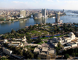
The modern era The confluence of the Kagera and Ruvubu rivers near Rusumo Falls, part of the Nile's upper reaches. Dhows on the Nile The Nile passes through Cairo, Egypt's capital city The Nile was, and still is, used to transport goods to different places along its long path. Winter winds in this area blow up river, so ships could travel up river effortlessly by using a sail, and down river using the flow of the river. While most Egyptians still live in the Nile valley, the construction of the Aswan High Dam (completed in 1970) to provide hydroelectricity ended the summer floods and their renewal of the fertile soil.
The Nile supports much of the population living along its banks, enabling Egyptians to live in otherwise inhospitable regions of the Sahara. The flow of the river is disturbed at several points by the Cataracts of the Nile, which are sections of faster-flowing water with many small islands, shallow water, and rocks, which form an obstacle to navigation by boats. The Sudd wetlands in Sudan also forms a formidable obstacle for navigation and flow of water, to the extent that Sudan had once attempted to dig a canal (the Jonglei Canal) to bypass the swamps.
Cities on the Nile include Khartoum, Aswan, Luxor (Thebes), and the Giza – Cairo conurbation. The first cataract, the closest to the mouth of the river, is at Aswan to the north of the Aswan Dams. The Nile north of Aswan is a regular tourist route, with cruise ships and traditional wooden sailing boats known as feluccas providing trips on the river. In addition, many cruise ships ply the route between Luxor and Aswan, stopping in at Edfu and Kom Ombo along the way. It used to be possible to sail on these boats all the way from Cairo to Aswan, but security concerns have shut down the northernmost portion for many years.
Drought during the 1980s led to widespread starvation in Ethiopia and Sudan, but Egypt was protected from drought by water impounded in Lake Nasser. Beginning in the 1980s techniques of analysis using hydrology transport models have been used in the Nile to analyze water quality.
The usage of the Nile River has been closely associated with the politics of East Africa and the Horn of Africa for many decades. Various countries, including Uganda, Sudan, Ethiopia and Kenya have complained about Egyptian domination of the Nile water resources. The Nile Basin Initiative is a program to promote equal usage and peaceful cooperation between the Nile Basin states. However, many still feel the Egyptian domination of the waters causes economic obstacles in the area.
[edit] Modern achievements and exploration The White Nile Expedition, led by South African national Hendri Coetzee, became the first to navigate the Nile's entire length. The expedition began at the source of the Nile in Uganda on 17 January 2004 and arrived safely at the Mediterranean in Rosetta, four and a half months later. National Geographic released a feature film about the expedition in late 2005 entitled The Longest River.
On 28 April 2004, geologist Pasquale Scaturro and his partner, kayaker and documentary filmmaker Gordon Brown became the first people to navigate the Blue Nile, from Lake Tana in Ethiopia to the beaches of Alexandria on the Mediterranean. Though their expedition included a number of others, Brown and Scaturro were the only ones to remain on the expedition for the entire journey. They chronicled their adventure with an IMAX camera and two handheld video cams, sharing their story in the IMAX film Mystery of the Nile and in a book of the same title. The team was forced to use outboard motors for most of their journey, and it was not until 29 January 2005 when Canadian Les Jickling and New Zealander Mark Tanner reached the Mediterranean Sea, that the river had been paddled for the first time under human power.
A team led by South Africans Peter Meredith and Hendri Coetzee on 30 April 2005, became the first to navigate the most remote headstream, the remote source of the Nile, the Akagera river, which starts as the Rukarara in Nyungwe forest in Rwanda.
